


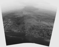
Originally uploaded by elvenstar522.
Picture of Titan’s surface taken from about 8 miles up. The picture shows what could be a “lake” of frozen methane, a clearly defined shoreline, and a mist-shrouded horizon. The picture below is an enhanced 3-D view of the same topographical features.
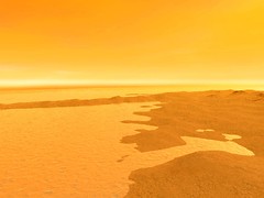
Originally uploaded by elvenstar522.
The pictures were NOT processed by NASA or the European Space Agency. Instead, the raw images were downloaded and processed using open source image technology. (HT: The Professor. Note the link is to Spaceref.com due to very slow page loading). Titan enthusiasts were impatient with the slowness with which NASA and the ESA were releasing the processed images from the Huygens lander so they took matters into their own hands.
The second picture in the sequence above is an extrapolated image using image processing software. It allows any image that’s scanned to be viewed from any angle. The color has been added according to the ESA color scheme seen in this picture.
Note the clearly defined channels running down the bluff into what scientists think may be a methane (or perhaps hydrocarbon) lake. The second picture shows what could be an island in the background.
Weird. Odd. Spectacular.


No comments yet.
RSS feed for comments on this post.
The URI to Trackback this entry:
http://rightwingnuthouse.com/archives/2005/01/17/how-about-a-house-on-the-lake/trackback/